
INTRODUCTION.
Variations in the routes and spread of surface water must have been a feature of this area since people first settled here; its a consequence of living in an area that supports a plentiful network of upland headwater streams. Presumably that is why the original village of Endon was located on the higher, better-drained sandy ground rather than the, often waterlogged, clayey soil in the valley. As with all settlements that date back before the time of the Domesday Book, local rivers and streams were important for domestic purposes, agriculture and industry. For instance the tannery, in part located in Hallwater, would have made use of the local natural water supply for processing leather; while Endon Mill, which utilized water power to grind corn, was situated on one of the tributaries of Endon Brook (which, as with all the local streams, ultimately flows into the River Churnet). And, before the advent of piped water supplies, local springs and streams would have provided water for livestock and drinking and washing water for household use.Originally,before they were modified by people, the streams and rivers would have taken whatever path was determined by the nature of underlying rocks, the overlying soils and the characteristics of the surface vegetation. Their flow rate depended on the steepness of slope, drag from obstacles in the channel (such as aquatic vegetation or pebbly bottom), the intensity and volume of rain and snowfall, and the rate of evaporation and transpiration. Hence, at a the time before humans settled in the area streams and rivers simply flowed along their natural way, narrow and fast in the upper catchment and slow and wide in the lowlands; meandering here, being braided there; sometimes fast at others slow; sometimes the water would have filled its floodplain at others it would have been a trickle in the bottom of the stream, or even dried up altogether. There would have been no such thing as a "flood"; that concept must have originated from the time that the natural variation in the space required by any particular water course impacted upon a built structure or farmed land. For instance if someone unwisely built their house right next to a stream in summer and the water level rose to inundate it during the winter, their home was flooded. Likewise if people settled by a stream that dried up or meandered away, they would move to be closer to the water as natural water sources would have been essential part of life.
Then people started to invent ways of controlling the flow, route, channel shape etc. of water courses so that the water flow could be used for all sorts of things; as a source of power, or perhaps to irrigate agricultural land or water their livestock; or as a way to wash a product as part of its manufacture; or even to improve riverine habitat and hence increase the productivity of a food source such as fish or eels. So we built and dug, diverted and dammed. We erected bridges to cross the water and when their presence was inconvenient we channelled water courses in pipes underground. We built dams and weirs to create deeper water. We changed the flow by installing water wheels to power mills. And we've canalised river channels in order to speed the flow of water through our villages and towns or dug leats to divert the water supply to another place. And, as a side effect of many of these acts, we polluted the water with wastes from houses, manufacturies and sewage.
At the same time we have modified all the other land in between streams and rivers.We've installed field drains and straightened streams to dry out soils for agriculture. In many places we've built on land near streams and rivers, in some cases burying ht e water so that it flows underground. On agricultural land we've removed trees, scrub and hedges or allowed them to fall into disrepair. And then we've allowed our livestock to graze, poach and compact grasslands or grown arable crops which speed the rainfall on its way down the slope. Often we allow animal manures from fields and from effluent stores to pollute our brooks and rivers. We are often unaware that our vehicles drip oil and fuel on to the roads which eventually washes, along with the rain, into our water courses.
All in all we have changed our streams and rivers so they are very different to their natural pristine state. And consequently local homeowners and businesses have suffered from flooding to their properties on several occasions http://www.leek-news.co.uk/Residents-livingin-fear-floods/story-20130139-detail/story.html.
Articles, such as the one referenced above, indicate that local parish councillors are of the opinion that the local brooks need to be dredged, realigned or treated to other "engineering solutions" to prevent flood damage to local properties. Some of them believe that controlling nature will make things better. They have pleaded to the Environment and Highways Agencies to remove streamside trees, dredge the brook and no doubt other projects involving diggers, chain saws and the like. However they are wrong.What we should do is to encourage or perhaps even oblige local landowners to manage the land around our village in such a way as to reduce the rapid runoff of water from rain and melting snow. In addition to this we should urge people who live in flood prone properties to mitigate for the problems caused by the impermeable surface associated with their property and ask them take measures to adapt to any flooding that does occur. As for upcoming planning applications to either modify existing buildings or build new ones (or other forms of build infrastructure) the planners should ensure that impermeable surfaces are minimised or mitigated for and either avoid building on floodplains or only permit building styles that can cope with being flooded. In fact, flooding of property has not been a very serious problem in Endon (unless of course you are one of the unfortunate people whose home was damaged), only a few houses have ever been inundated. But, we live in an area of headwater streams whose management has an effect on settlements further down the catchment. Apart from streams which originate in the Stockton Brook area (which are part of the River Trent catchment) the local brooks all flow into the Endon Brook which itself flows in to the River Churnet. The Churnet flows into the River Dove (at Rocester) and this in turn eventually meets the River Trent. So, what happens to the land around here potentially has serious consequences for people who live miles away, and this is why local parish councillors can only have a small role in decisions as to how these water courses should be managed. The Environment Agency must be the best people to decide how the land should be managed. They have expert hydrologists (with state of the art computer modelling), freshwater ecologists and water engineers (who, hopefully, are sympathetic to the interests of wildlife) . If we want local streams that are rich in wildlife and are managed to reduce the chances of damaging floods, we need to listen to them, not the uninformed opinions of self-appointed so-called representatives of local people.
LAND MANAGEMENT IN ENDON.
Here are some photos of streams, fields, roads and other features in and around Endon. Some show where the land management (or lack of it) is likely to help to reduce the chances of flooding of businesses and homes, while others show the opposite. The captions describe what is the probable consequence of the way each feature is treated. And, for any reader who is interested here is a presentation prepared by the Environment Agency which provides information as to why dredging water ways is not necessarily the solution to flooding in urban areas To dredge or not to dredge?
HEADWATERS
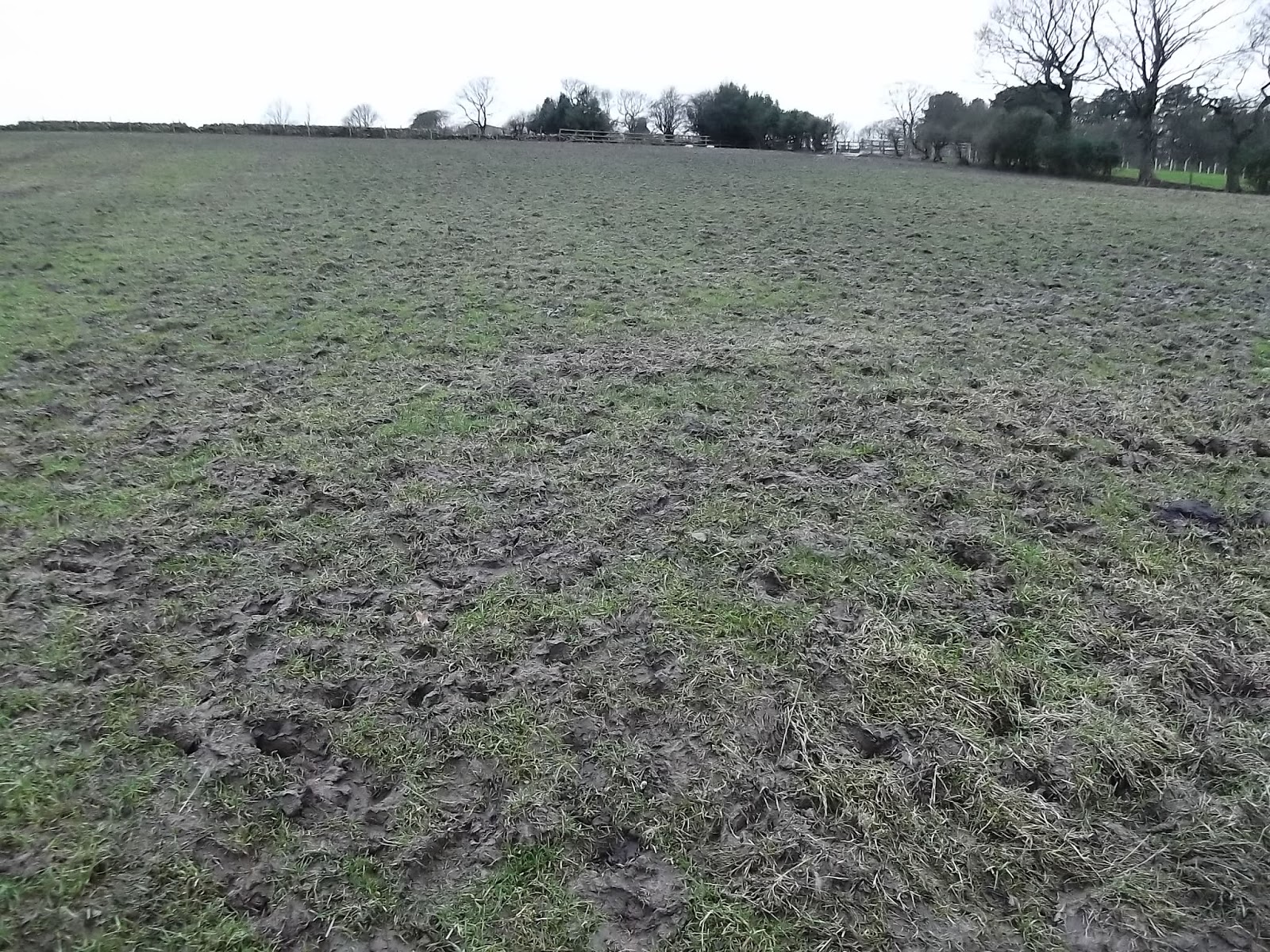
These top two photos below show some of the landscape in the catchment of the brook that eventually flows through Endon old village at the ford. The fields are mostly small, hedged and consist of relatively little improved pasture with rushy and tussocky patches. Compared with some agricultural land in the UK the soils don't appear to be particularly compacted by animal trampling or tractor wheelings. The ground is uneven and there doesn't seem to have been a great deal of levelling and infilling of hollows (a common habit of some farmers) . Some of the fields are more intensively managed by being used for silage production, but at present I would say these are in the minority. All the fields slope, and so of course, much precipitation will run off the surface. However, I would judge that some of the water, when the ground is not saturated, will percolate down through the soil profile (as the surface is not too compacted and the rough vegetation will delay its progress downslope). In addition some water will be temporarily trapped within the hollow areas of the undulations and on the upslope of hedges and tree lines. During light showers when the temperature is sufficient, some precipitation may be caught on and then evaporate off the surface of vegetation, and the presence of hedges, trees and rough herb vegetation will aid that process. Though I haven't seen along its whole length, looking at the 1:25000 OS map, the stream itself does not look as though it has been too modified; it meanders along following the natural valleys. In places there are streamside trees, giving a relatively natural appearance. All in all this area is relatively well managed from the point of view of flood prevention. It is producing some agricultural products whilst also delaying the flow of precipitation into water courses. Contrast this with some of the photos below in which sloping fields are almost bare of vegetative cover during the wettest seasons, and ones where the slope profile is being smoothed out by either infilling of a hollow or reshaping the hillside (as in the case of the golf course).

Roughly grazed smallish fields with hedges and trees help to delay runoff from precipitation.

Rushy pastures, trees and shrubs can slow down water flow during rain fall or snow melts. Also plant roots create pores and cavities in the soil which aid water percolating downwards rather than running over the surface.
Here is a photo of the ford. It is obvious that the buildings adjacent to the brook, many of which which are more that 100 years old, are constraining the natural flow of the water course. In spate the water is forced to rise up the channel, and if there is enough water available it will top the channel and spill over into residents gardens and even houses where the land lies in such a way as to allow that to happen.

The unnaturally shaped channel of village brook just upstream of the ford.

The ford and the brook in its constraining channel. This constraint, or pinch point, is the real reason that the water backs up and floods some of the nearby properties. Dredging the brook 100 or so meters further on is going to have absolutely no effect on preventing flooding of adjacent houses.

The brook between houses on its way to the bridge under the A53.

View over the housing estate through which the brook flows to the A53. The brook runs in a narrow channel between some of the houses. As far as I know none of these have ever flooded, just the ones further upstream, by the ford. However, these houses themselves are built on the stream floodplain and precipitation running off the impermeable surfaces on this small development will contribute to the possibility of flooding properties downstream of these. In fact, in this case that probably does not happen as the next settlement is Denford and between these houses and there is the large area of grasslands that hosts temporary pools whenever we have heavy or prolonged rainfall. These pools store the water so that it flows away over days or weeks rather than hours. There are two photos of that area below. One shows the land during a dry period, the other after a lot of precipitation.

The village brook immediately before the bridge under the A53.
The photo below shows a digger taking silt from below the bridge under the A53. During that work the soil in the field was damaged by the wheels of the tractor, fossil fuels were burned (fossil fuels that are contributing to the CO2 emissions which are in turn, contributing to climate change and the resultant increased rainfall intensity - in other words the dredging probably ins a very small part increased the risk of flooding in the village!!). The damage to the soil may have cause more soil to enter the brook and therefore increase siltation, thereby, according to some residents, contributed to the incidence of flooding. The dredging has potentially managed to achieve a positive feedback loop folks!!

The, in my opinion, irrationally motivated "dredging" work under the A53 February 2014.
STREAMS AND BROOKS
The photos below show modifications which have been made to the Endon Brook in recent years. These changes would not have affected the area around the ford as they are either on a different tributary (in the case of the photos showing willow tree removal and pond filling in) or downsteam of the ford (in the case of the reprofiling)
This photo (above) was taken in 2008. The stream channel has been reprofiled into the classic trapezoidal cross section which was frequently the standard means of controlling rivers in the 1980s. This method is now known to have caused enormous damage to the natural functioning of water courses. Not only is it damaging to wildlife it simply increases the rate of water flowing through the channel. The outcome is increased likelihood of flooding of properties downstream. Downstream of this location is Denford, some of the properties there, notably the Hollybush pub, has flooded on a number of occasions. I believe all the streams in the Endon, Denford and on to the River Churnet valleys, perhaps as far as Rocester, have been dredged into an unnaturally deepened, trapezoidal cross section. This means that, during average flows the water level is within a relatively deep channel. These days most people probably think that this is the natural form of a stream or river, whereas in fact they would often be in a channel with gently sloping sides in which the water gradually rises and spreads out during heavy rainfall. The trapizoidal channel form has reduced the amount of land surface area devoted to a river an, for any given area, it takes more water that the natural form, but up to a certain point, when the capacity is exceeded the river overtops, often spilling on to built up areas or cropland that were formerly the river's flood plain. See the next....photos below.

Bankfull Endon Brook by Dorian Way.

Endon Brook by the "wash" that holds many litres of water when the brook overtops during periods of complete ground saturation and high rainfall. This photo also shows the unnatural shape of the stream channel, which has probably been straightened as well overdeepened. This profile means that there is little variation in the shape of the cross-section of the channel which in turn gives little opportunity for riparian vegetation to become established at the stream sides; this shape does not provide the right habitat (shelves of shallow water) suitable for emergent aquatic plants such as Common Reed or Yellow Flag Iris. However these plants can be found growing in the edges of the nearby Caldon Canal (when the canal has not been recently dredged that is!).

The unnaturally overdeepened channel of Endon Brook at Hazelhurst Junction.
ACTIVITIES THAT INCREASE RUNOFF - AGRICULTURE.

This photo (above) was taken in September 2007. It is an old Crack Willow tree and is one of a number of these that used to grow alongside the Endon Brook. The trees showed signs that they had been pollarded in the past, a traditional form of tree management. There were regularly spaced along the brook and I suspect were planted to reinforce the banks against erosion this was common practice at one time). The trees were a significant part of the local landscape and would have been valuable wildlife habitat. They may have helped with slowing down infiltration rates of precipitation and their fallen branches, had they landed in the brook would have provided shelter for fish and other aquatic creatures and also helped slow the flow. But they were clearly in the way. So they were grubbed up and burned; the remains being buried in a field pond for good measure. Another example of a positive feedback loop here as the wood of the tees would have been a carbon sink. Burning them released more CO2 to the atmosphere, and in case you didn't already know by now, CO2 leads to climate change, which causes increased intense rainfall in Britain, which causes flooding!

The final day of life for a veteran willow tree.

Several willow trees and a hedge were ripped out and burned on this occasion.

Does this count as a satisfying day's work for this farmer?

The former field pond (which is marked on the older OS maps)- became a grave for the lovely old willow trees!
After the trees, hedge and pond were eliminated field drains were installed (at times tractors where being driven in the area where a pair of Lapwings were nesting, I watched the birds mobbing the vehicle, but took no photos on that occasion). Of course the water from the drains now contribute to the increased flow rate of water in the brook! Had the trees and hedge, pond and rougher grassland remained, the infiltration rate would be slowed, and hence risk of flooding downstream reduced. Farmers receive £1,000s every year in EU subsidies and yet, unless they are in a specific agri-environment scheme (for which they receiver higher payments) they are given free reign to manage their land in a way that contributes to local floods and damages the interests of wildlife and diminishes the beauty of the landscape!
Clearly the previous attempts to dry out the soil have not been entirely successful, as further land drains were installed this spring (below).

Here, below, is another farmer draining his/her land, damaging wildlife (this time a rushy ciorner of a field that has been a Curlew* nesting site) and adding to the speed of water running off his fields. Presumably the productivity of that field is increased somewhat. But remember, he/she is also getting subsidies from us taxpayers, every year, just for owning that land. What I wonder are we getting in return - not wildlife or flood prevention, that's for sure! This field is between Endon and Longsdon. * Curlew is now on the UK's Red List of Birds of Conservation Concern

Below is a heavily poached sloping field near Bagnall. It looks like this every autumn and winter. This has very little cover so any rain falling on this field will run straight off into the nearby stream, taking some soil and muck with it. Soil loss is a big issue in the 21st century - see this report. The resultant silting or water courses and the nutrients form animal manure harm aquatic wildlife. Plus, this poor management adds to the possibility of flash floods in the vicinity. Does the farmer care? Clearly not.
ACTIVITIES THAT INCREASE RUNOFF - COMMERCE.
This is Greenway Hall Golf Club course. This year the club has made some considerable changes to the grasslands that form the golf course. This has involved hours of earthmoving and reshaping of the slopes. The scars are obvious, as is the effect of any rain on these bare hillsides. They will grass over of course, but with a close-cut sward that will not slow water flow. I am amazed that this has been allowed to proceed, given that we live in a flood risk area. Did the local councillors object I wonder?

ACTIVITIES THAT INCREASE RUNOFF - BUILT INFRASTRUCTURE.
This is the car park of St Luke's church. Originally it had a rough stone chipping surface but was tarmacked within the last few years. It is about 10m x 40m and impervious. Rain or snowmelt will run straight off down the nearby sloping road and then into the storm drains - thus adding more water to a system that is already unable to cope. How did this get permission I wonder? Did local councillors consider the extra contribution this water would make to flash foods?


During heavy rain water from all the hard surfaces within the housing estates in Endon, most of which are on slopes, runs down the roads and into storm drains like this one. This one empties into the Endon Brook where it passes under Station Road. This, of course fills the stream channel which has been deepened some time in the past, in order to accommodate all the water. However, in this case building on the flood plain may not have resulted in damaging floods downstream, because the Endon Wash (as I call it) stores huge volumes of water. But before the water from a heavy rainfall gets to Endon Brook there is some delay as it has to find its way down a storm drain. Clearly on some days there is not enough capacity and large puddles form on the road. In the summer of 2012 water from some local roads overflowed off to people's gardens and in a few cases their homes. Had we anticipated increased intense rainfall in the 1970s and 1980s maybe the planners migh not have allowed properties to be built so close to headwater streams. But, they are there now, and so all that can be done is to adapt to the predicted weather patterns due to climate change and take these changes into account whenever further buildings are proposed.

ECOSYSTEM SERVICES - HOW NATURE HELPS PREVENT DAMAGING FLOODING
Below Endon "wash" during a dry period.

Endon "wash" stores recent heavy rain water. The Endon Brook runs through this area and it overtopping its banks is the cause of the temporary pools,shown below, which, hold the water back so that it gradually seeps away or moves downstream thereby reducing the chances of damaging flash floods downstream. These pools are great places for wildlife. Sometimes 100s or Lapwings, scores of Wigeon, Teal, Mallards, Snipe and other birds benefit from their presence.

These next two photos show some marshy grassland between the Caldon Canal and the A53. It is bisected by a popular footpath from the main road to Stanley Moss. This is one of the areas proposed for housing by the local council. Personally I am not against building more houses in Endon, however of all the proposed sites this is the one I objected to. Partly because it is one of the less improved fields in the area, and therefore relatively good for wildlife, and partly because it is an attractive walking route for children who live in Stanley or Stanley Moss to get to school. However, if houses were built here the footpath and the trees may be saved, but nevertheless, I think there are less attractive places that could be used for housing instead. But there is another reason that care should be taken before building here and that is because if obviously acts as a temporary store for precipitation during wet weather. I wonder how many extra cubic metres of water would be forced in to the tiny brook that runs along the line of those Alder trees if the area is mostly covered by the hard impermeable surface associated with houses and driveways? Although, the fact that the area already has periods during which it is under shallow pools does not mean it could not be built on without increasing the risk of damage to properties. For instance in Holland innovative building designs have been developed to cope with this eventuality http://www.bbc.co.uk/news/world-europe-26302176 . Also, the possibility of flooding to settlements downstream can be soemwhat reduced by use of green roofs, permeable surface to driveways, sustainable urban drainage systems etc. We just need local planners to ensure these features are incorporated into new buildings.


Finally these tow last photos show trees overhanging water courses, and in the second dead branches have fallen into the water. In the 1980s, when it was all the rage to engineer artificially created trapezoidal river channels to speed the flow of water, the rivers authority also cleared streams and rivers of nearby trees and shrubs. Any in-channel wood was said to slow the flow, and this was thought to be bad. In fact the opposite was true. Woody debris in water courses helps to slow the water flow as water gets trapped behind the log. Of course if you have a constrained channel where large volumes of water has no-where to go but up having an obstruction in the way could be a bad thing as backed up water could overtop the bank and flood properties or farmland. However, if you had let the river run free it would be wandering about throughout the landscape, thereby increasing the volume of water it could accommodate.

This photo below is actually the River Churnet, further downstream from Endon. The dead wood lying across the river here may act to deflect the water to the extent that it erodes a curve in the river channel. This is one of the ways in which rivers form meanders, thereby increasing their capacity for holding water. Meanders, riffles, pools, braided channels are all natural features of rivers and streams.They vastly improve the habitat for wildlife and the river's capacity to hold water. Rather that persisting with the discredited policy of the 1980s of channelising rivers which actually reduced their volume, we should let the streams and rivers roam free across the landscape so that natural hydrological processes take charge. In this way water from the intense and more frequent rains we hare led to expect as a result of our changing climate will be less likely to flood our properties and more likely to be wonderful areas full of wildlife!


Useful reading:
Holmes, N. and Raven, P.,(2014) Rivers British Wildlife Publishing
Moss. B., (1998) Ecology of Freshwaters, Man and Medium. Past to Future Blackwell Publishing
A report: Floods and Dredging - a reality check - produced by the Chartered Institute of Water Engineers and Managers it is available from this link http://www.ciwem.org/media/1035043/floods_and_dredging_-_a_reality_check.pdf
Miles King blog
Mark Avery blog
George Monbiot blog


